Multi-Itinerary Optimization (MIO) API
The MIO API is powerful routing API that automates the process of building itineraries for multiple agents and optimises their routes across multiple destinations. If you are building a multi-stop/multi-route application, Bing Maps Multi-Itinerary Optimization (MIO) API supports up to 200 agents and 2000 waypoints, and calculates route optimisation for multiple agents, shifts, routes, traffic conditions, service time windows, and more, to save travel time and fuel costs.
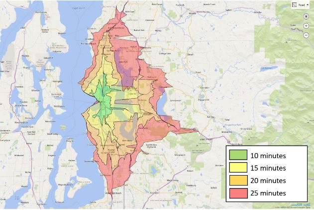
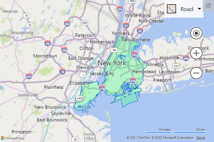
Isochrone API
Calculate the area that can be travelled to within a specified distance or time and visualise that area on a map. The isochrone maps provide accurate polygon shapes with customisable parameters such as arrival or departure times, predicted traffic, and user’s location. The Isochrone API optimises travel times for modes of transportation, including walking, driving, and public transit. Isochrone maps use cases include:
- Stolen vehicle recovery: Use a time-based search to outline how far the vehicle could have travelled.
- Real Estate: determine potential locations near workplace, schools, amenities.
- Zoning and transport planning: use criteria such as population and amenity locations to determine the area for vehicle service
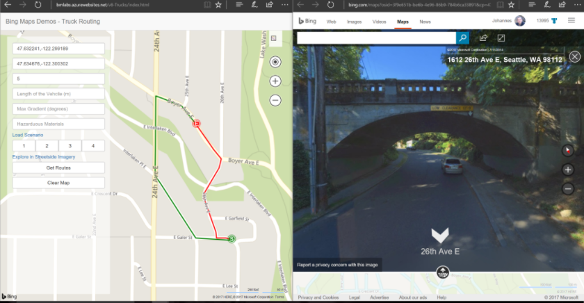
Truck Routing API
Choose Bing Maps Truck Routing API to create customised routes that can be travelled by trucks and commercial vehicles. Using a series of waypoints and attributes, the truck routing software takes into consideration the height, weight, and length of the vehicle, and includes information such as road restrictions, traffic conditions, legal restrictions including HAZMAT, waterways, tunnels, travel distance and travel duration. Cut down on transportation time by optimising the route that matches the vehicle’s specifications.
Snap to Road API
The Snap to Road API takes GPS longitude and latitude data points and returns a list of objects that are converted and snapped to the nearest roads on a map. The snapped routes provide accurate route tracking for fleet management and asset tracking solutions. The data includes the names of the roads and associated speed limits to help determine driver behaviour.
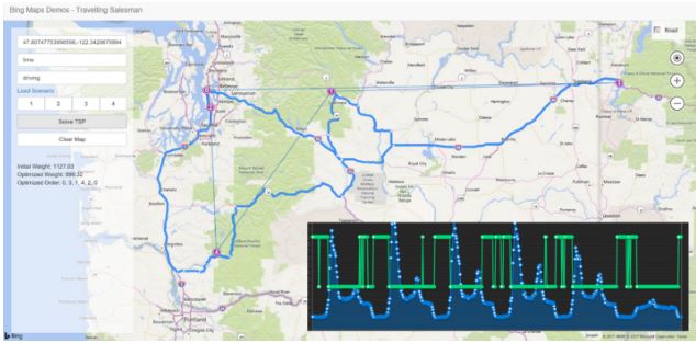
Distance Matrix API
A routing solution that calculates the best route possible based on a matrix of distance and travel time for multiple destinations. The routing API optimises across specific parameters including method of transportation such as driving, walking, or public transit, start and end time, and historical traffic. Distance Matrix helps solve the travelling salesman challenge by effective route planning, saving time, money and resources. Distance Matrix use cases include:
- Supports up to 10 agents and 100 waypoints.
- Taxi/car service application: see the driver’s location and estimated time of arrival.
- Retail: optimise deliveries from distribution centres to retail locations.
- Field services: route the closest technician to the client for service.
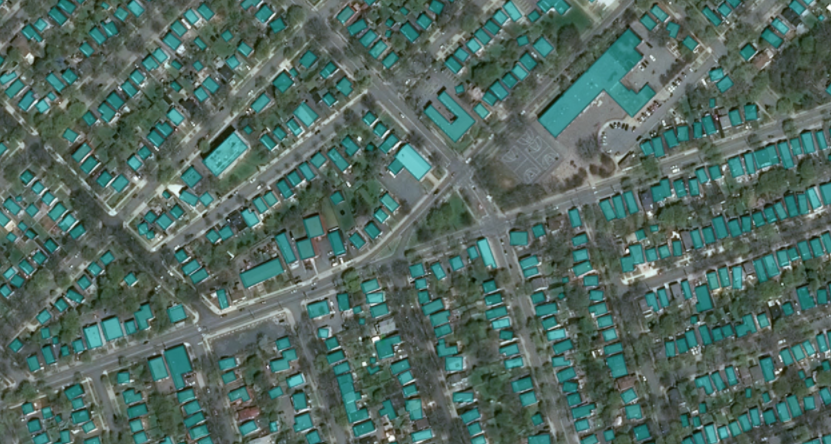
Building Footprints
The most up-to-date building footprint data covering global regions.
Microsoft has made significant investments in deep learning, computer vision and AI that have been applied to mapping to generate high-quality building footprint data at scale.
The Bing Maps team has a goal to increase the coverage of building footprints available as open data for OpenStreetMap and humanitarian efforts. Millions of worldwide building footprints datasets are now freely available for download and use under applicable licence.
Open data regions currently available:
- North America: United States, Canada
- South America
- Africa: Uganda and Tanzania, Nigeria and Kenya
- Australia
Geocoding
Geocoding converts a street address or location into a set of geographic co-ordinates. Bing Maps provides three different types of geocoding: address geocoding, reverse geocoding, batch geocoding. Bing Maps Geocoding coverage is available in more than 100 countries.
- Reverse Geocoding allows you to retrieve the nearest address for given longitude and latitude coordinates.
- Batch Geocoding saves time and increases efficiency.
Bing Maps Rooftop offers the highest level of geocoding accuracy support. Instead of interpolated results, addresses are resolved to the latitude/longitude co-ordinate at the centre of the address parcel (property boundary) with high precision post code.
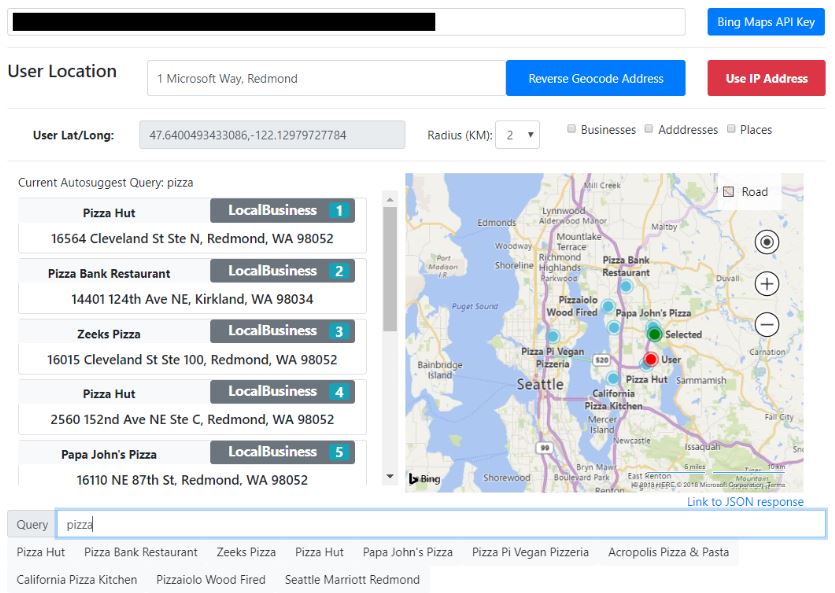
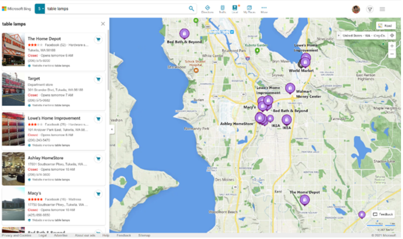
Local Search API
Benefit from the additional location intelligence of local search to get actionable insight into businesses and entities nearby.
The Bing Maps Local Search API is a simple-to-use REST API that provides insights into businesses and entities that can be reached by car, on foot, or public transit. Query for businesses by name, category or free text; score the attractiveness of a location based on the proximity to points of interest.
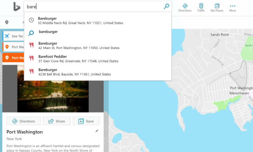
Autosuggest API
The Autosuggest API is used to return a list of suggested entities based on a user’s partial query. The service can return three possible entity types: Addresses (including roads), points of interest, and Businesses, which are currently only available in the U.S. A maximum of ten autosuggested entities can be returned per request, and the returned entities can be delimited by country and culture.
Time Zone API
Represent global time zones with the Windows and IANA Time Zone standards, which provide a well-defined structure for representing global time zones. It can get complicated when different regions change the way they apply daylight saving time. The Bing Maps Time Zone API makes it easy to find a time zone and daylight savings time for a location by query or latitude and longitude co-ordinates. It can also convert datetime stamps to local time zones with daylight savings time information or by retrieving a Time Zone ID.
Spatial Data Services
Get three key capabilities with the Bing Spatial Data Services (SDS): Batch geocoding, point of interest data (PoI), and the ability to store and expose your spatial data.
You can submit large numbers of addresses for batch-geocoding and GPS-coordinates for reverse geocoding. Download the results or store your spatial data and retrieve your PoI through the SDS Query API. Outside of your own PoI, you can also query PoI from public data sources grouped into categories.
Locations API
Use high-powered geocoding and reverse geocoding with the Locations API.
Find a location based on co-ordinates (latitude and longitude) and other values like postal code, address, and query string.
For a reverse geocoding service that gives you insightful information about a specified location use the Location Recognition API. When given location co-ordinates (latitude/ longitude), the Bing Maps Location Recognition API returns a comprehensive description of the location along with points of interest.
Top 5 reasons to use Bing Maps
Maps SDK for Android and iOS
SDKs for Android and iOS to integrate fully featured map controls into mobile applications including positioning, 3D mapping (3D Native support from Windows UWP control) and voice guided turn by turn navigation, with a consistent look and feel across web, Windows, and mobile.
You can add to both road and aerial views with worldwide 3D elevation data employing the Digital Elevation Model. You can also add content to road maps with symbolic 3D building. If 3D is not necessary for your scenario, the SDK supports a standard Web Mercator projection.
Use Cases

Routing for deliveries
Automate schedules for multiple field teams and optimise their routes across multiple destinations for improved performance including last mile.
Asset tracking
Track and monitor your fleet of vehicles, food delivery services, shipping containers, or mobile workforce in real time on a map to improve performance and customer service.
Retail and eCommerce
Identify new retail locations based on demographics, warehouse and public transport locations. eCommerce sites use store locators, and validate customer addresses with geocoding.
Location Intelligence
Visualise sales results and other KPIs by location and analyse demographics, competitor analysis, and sales trends. Use custom thematic maps to build contextually relevant applications.
Why Grey Matter?
- As the Global Microsoft Bing Maps authorised distributor, you have access to the world's most knowledgeable mapping team outside of Microsoft.
- Our experienced team will ensure you have the best licensing advice to remain compliant.
- We can provide you with guidance on best practice so you are charged for only what you need.
- Your technical questions can be promptly answered via our direct access to Microsoft.
- Our services team can consult on your infrastructure, modernisation and security.
- You can start building your solution with a Bing Maps key, get in touch with us to help set you up.
Contact us
Get started building your solution. Complete the form and one of our Bing Maps specialists will get in touch to discuss your use case with you and help get you set up. Alternatively, you can:
Call: +44 (0) 1364 655133
Email: mapping@greymatter.com
By submitting this form you are agreeing to our Privacy Policy and Website Terms of Use.